CHAPTER 12 THE ROUTE OF THE SURREY IRON RAILWAY
No contemporary large-scale map of the whole railway as "built has come to light, but its course is clearly shown on. the tithe maps, of various dates c.mid-l840s, of the parishes through which it passed. The Parliamentary Deposited Plans of the Croydon & Epsom Railway, the Wimbledon & Croydon Railway, and the Richmond Railway, show portions of the route, and parts are shown on sundry contemporary estate maps and property conveyance plans. From these maps, and from the first edition (c.mid-l860s) six-inch and 25-inch Ordnance Survey maps, which show related property boundaries, it has been possible to plot the route with tolerable accuracy on to current maps, and thus ascertain its relationship to present-day roads, railways, and other features.
The route is also shown on maps in "Further Notes on Early Railways in Surrey", by Charles E. C. Townsend (prepared by Charles E. Lee) in the Transactions of the Newcomen Society, Vol.XXVII (1949-50 and 1950-51). and in "Retracing the First Public Railway", by Derek A. Bayliss (2nd. edition, 1985). Occasional references are made to these, identified as "Townsend" and "Bayliss" respectively, in both this and the following chapter, when my interpretation of the route differs from one or other of them.
 |
Legend [78.8kb] |
1) WANDSWORTH TO MITCHAM
The Deposited Plan of the Surrey Iron Railway showed an oval- shaped basin at Wandsworth about 100 yards long, centred about 300 yards from the bank of the River Thames, and to the east of the River Wandle. But as actually built, the basin was narrower and much longer, extending from the eastern arm of The Causeway as far south as the present Armoury Way. It was described by James Malcolm as being "sufficiently capacious to contain 30 or more craft of various sizes."[1] The Causeway was carried over the north end of the basin by means of a swing bridge, and from this point a canal ran northwest to the Thames, with a tide-lock near its mouth.
 |
Surrey Iron Railway canal at Wandsworth [207.2kb] |
The Surrey Iron Railway dock and basin area as shown in Fig.6 is based on a plan accompanying the sale particulars of 1848 [2] , modified slightly in deference to other contemporary plans and early Ordnance Survey maps. Unfortunately, none of these sources shows the full extent of the track layout or accessories. Farey mentioned sidings,.
"which are very numerous in the company's yard, by the side of their basin", and a turntable, by which wagons were turned to back onto a staging projecting over the basin [3]. Malcolm referred to a branch from the railway to Shepley's "extensive range of newly-erected warehouses"[1], and the route of this can be deduced, as the location of the warehouses and a bridge over the Wandle are known. This branch had apparently been taken up before 1835.
In fact, the actual commencement point of the railway is uncertain. Some maps show it as being by the: side of the canal, just south of the lock, while others place it further south, beside the basin, which seems more likely. From whatever point, the railway ran alongside the west side of the basin to the dock gates, which were situated at about the junction of the present Ram Street (formerly called Red Lion Street) and Barchard Street.
| Lower Mill, Wandsworth |
McGow 49 |
Just south of this mill site, a viaduct carries the Windsor branch of the former London & South Western Railway across the valley and over the dock and basin site. The original structure, erected during 1845, was described as "a splendid viaduct of 22 arches, three of which are of 70 feet span, the whole length of the work being about 1000 feet." [4] The railway was opened as the Richmond Railway on 27 July 1848, a few weeks before the Surrey Iron Railway was closed.
| Middle Mills, Wandsworth |
McGow 48 |
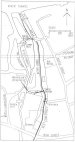 |
Fig. 6 - S.I.R. Wandsworth dock [78.8kb] |
After George Shepley's death in 1807, his half-share in the property was offered for sale by auction in March,1808, at which time the mills were said to be "working six pairs of stones and now in full trade." [5] The mills were reconstructed in 1818, but the windmill ceased operating about 1825 and was probably demolished soon afterwards. The millers from about 1816 until 1826 were Samuel and Edward Kingsford.
The mill was then bought by Daniel Watney, senior, and, after his death in 1831, passed to his son James, who worked it in conjunction with the Lower Mill. The Middle Mill was also demolished early in the 20th. century.
On the east side of the Wandle, between the Middle Mill and Wandsworth High Street, was a dye-works. In 1724 they were being operated by Edward Applegarth, and from 1743 until 1747 by Thomas Cecil. He was succeeded by John Spence, who "carried on a very considerable trade in dying scarlet cloth for the East India Company." Joseph Barchard was in occupation from 1761, and the works were later managed by successive members of the Barchard family. By 1799 the firm was trading as Barchard, Hilton and Platt. John Barchard and John Platt were proprietors of the Surrey Iron Railway.
| Dyeworks Near High Street Bridges Wandsworth |
McGow 47 |
This brewery came into the possession of Somerset Draper on the death of his father in 1645, and remained in the Draper family until it passed to the Tonson family in 1736. In 1763 it was bought by Thomas Tritton, who owned a brewery at Ashford in Kent. Tritton's younger son George, who had worked for a time at the Ashford brewery, inherited both breweries after his father's death in 1786. He died in March, 1831, and the Wandsworth brewery was then sold to Anthony Bainbridge and Charles Allen Young, whose father Florance Young had shares in the railway. Their partnership was dissolved in 1864, and Charles Florance Young, son of Charles Allen, then carried on the business as Young and Company. It has remained in the Young family ever since.
| Calico Printing Works, Wandsworth (Later Gardiner's) |
McGow 46 |
The present brewery shop, at the corner of Ram Street and High Street, is on the site of the original Ram Inn. At some time a canal or cut was built from the south end of the Surrey Iron Railway basin into the brewery premises, and a swing bridge was provided at the point where the cut joined the basin, to carry the branch railway leading to Shepley's warehouses.
By 1865 the dock and basin had been acquired from Watney and Wells by William MacMurray, a paper maker, and were used extensively for the unloading of esparto grass for use at his Royal Paper Mills in Garratt Lane (which we shall come to shortly). The basin and canal connection to the Thames became popularly known as "MacMurray's Canal" at this period. Young's Brewery and the Wandsworth Gaslight and Coke
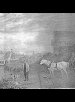 |
Plate 6 Surrey Iron Railway dock at Wandsworth [207.2kb] |
Company were then also largely dependent on the dock facilities, for deliveries of coal.
The Wandsworth Gaslight and Coke Company had been founded in 1834, and their gasworks was built on land between the dock area and the former Forth Street, immediately south of where the Richmond Railway was later to run (see Fig.6). By the 1860s the premises had been extended to the northwest. In 1900, Paley was able to state that the dock "still exists with little alteration" [6] , but in the 1920s the gas company, now named the Wandsworth, Wimbledon and Epsom Gas Company, bought the dock property in order to extend the gasworks further. By this period little traffic was being carried by water, and in 1932 the basin and canal were filled in and built upon. The then-redundant cut into the brewery was filled in soon afterwards. The gasworks were closed in the 1980s, and the site of the dock and basin is now occupied by commercial and industrial premises.
Plate 6 is from a painting, believed to date from the 1820s, giving a view of the dock area looking north from inside the entrance gates. The swing bridge on the left is that at the south end of the basin, with part of the cut into the brewery in the left foreground. In the background, behind the bridge, is the Lower Mill.
From the dock gates the Surrey Iron Railway ran along the west side of Ram Street and across Wandsworth High Street. In 1900 Paley noticed a 150-yards length of kerb along Ram Street (then named Red Lion Street), constructed of sleeper blocks from the railway, and some built into the wall of a forge close by [6]. It was, no doubt, i from one of these sources that the nine blocks we can see today, built in a pyramidal pattern into the Ram Brewery wall on the west side of Ram Street, with an identifying plaque, were obtained. There are more blocks in the brewery yard behind the wall.
From the crossing of the High Street, the railway ran southwestwards and soon crossed the Wandle over a timber bridge. It then swept round to the southeast to run close to the west bank of the river, before turning to cross it again on another timber bridge, on the site of the present bridge carrying Mapleton Road over the river. The railway carried on to cross Garratt Lane at an angle, then turned to the southeast to run adjacent to the east side of the road.
Both Townsend and Bayliss show the route of the railway between the High Street and Garratt Lane as a regular curve away from the Wandle, but contemporary maps indicate that it ran adjacent to the west bank of the original course of the river.
| Upper Mills, Wandsworth |
McGow 45 |
They continued to work as corn mills for many years, but by 1721 they had been converted into leather mills, in the tenure of Jacob and Michael Papineau. By about 1729 the western mill had been converted to copper milling. In 1768 the mills were acquired by George Shepley and Hugh Mears, who converted the copper mill to corn milling, at which time the engineer John Smeaton designed three new wheels, probably the total for both mills. The corn mill was operated by Richard Shepley, George Shepley's brother, until his death in 1781, and then by his son Richard until he became bankrupt in 1791. The leather mill was converted to oil milling
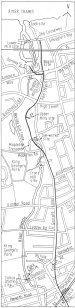 |
Fig.7 Route Map (A) Wandsworth to Earlsfield [78.8kb] |
The corn mill was operated by Jacob John Papineau after 1791, and following George Shepley's death in 1807, the oil mill was worked by Francis Atkinson. By 1817 Daniel Watney senior was the owner of the mills, and by 1823 the oil mill had been converted back to corn milling. After Watney's death in 1831 the property passed to his son James, together with his father's shares in the Surrey Iron Railway.
The mills remained in the possession of the Watney family, together with the Lower and Middle Mills, until the mid-l870s, when they passed to the Aerated Bread Company. Later they were worked by Pimm and Company, and as the Wandsworth Flour Mills they continued in operation until a,bout 1930. The buildings, by then derelict, were demolished in 1962.
| Dye Works, Garratt Lane Wandsworth (Later Gardiner's) |
McGow 44 |
To the west of this establishment, on a site approximately on the western edge of King George's Park, there was a calico-printing works established in about 1687 by John Ousley. By 1792 Henry Gardiner was the calico printer here, when his works were described as "of considerable extent and employs about 250 hands." [7] This was on a side stream of the Wandle, near Downe Lodge, which Henry Gardiner had built in about 1790 as his residence. Downe Lodge still survives as No.33 Merton Road, now converted into flats. Gardiner also rented some land on the west side of the Wandle, opposite the Upper Mills.
| Calico Printing Works, Garratt Lane, Wandsworth |
McGow 43 |
Just past the footbridge over the Wandle to the south of Mapleton Road a bypass channel formed an island and here is part of the premises of the Inwear buildings. This is the site of a long succession of mills, and was probably that of a mill mentioned in the Domesday survey of 1086. Originally a corn mill, it became for a time a fulling mill, then reverted to corn milling. By 1629 there were two mills here, and one of them was converted to copper milling about 1655. Later, they were both copper mills, operated by the Robinson family. In 1777 the lease of the mills was taken by James Henckell, a City merchant, who converted them to iron mills. Later, Henckell went into partnership with Thomas DuBuisson and George Day. Of these Day was the practical ironfounder, and when the partnership was dissolved in 1810 Day continued the business in partnership with his sons George and Samuel. George Day senior was a proprietor of the Surrey Iron Railway. He died in 1812 and the business was then conducted by his elder son George.
Several broadly similar descriptions of the operation of the iron works were given by contemporary observers, the following account was written by Hassell in 1817:
"At the iron forges a.nd mills are cast shot, shells, and cannon, and other implements of war: - in another part, wrought iron is manufactured, and the wonderful effect of mechanical power is exemplified in the splitting of iron bars of considerable length; also, a pair of shears which cuts asunder iron, more than two inches thick; and likewise a working hammer which weighs near six hundredweight." [9]
George Day's lease expired in June,l8l6, and an advertisement inviting tenders for a subsequent letting gave as one of the advantages of the premises "a communication with the River Thames by an iron railway." [10] In fact, Day renewed his lease on a yearly basis. He was evidently experiencing financial difficulties in 1829 when he was fined for not paying Poor Rates, and in 1830 his premises were described as being in, "a delapidated condition .... the centre of the north portion of the premises was the only part occupied." [11] In 1836 the machinery and utensils of the mill were advertised to be sold by auction [12].
That same year the premises were acquired by Thomas Creswick, a well-known manufacturer of, among other things, playing cards, who converted the mill to paper-making. After his death in 1840 the business was carried on by Sarah Creswick. By this date John Watney had become the actual owner. The works were later occupied by a succession of paper-makers, until in 1854 William MacMurray moved to there from Esher and began to operate name of the Royal paper Mills. His use of the former Surrey Iron Railway dock has been mentioned previously.
The premises, greatly extended from the original iron mill, were demolished in 1910, but later rebuilt and occupied by a succession of various manufacturers, until finally demolished in the early 1980s. Iron Mill Place, the name of a short road on the other side of Garratt Lane, commemorates the former use of the site.
Just to the south of this mill was a calico-printing works. This was originally a bleaching ground, established by Richard Pillett in 1657. By 1736 John Page, a calico-printer, was working here, until about 1760. He was followed by James Plank, and after his death in 1771 the work was carried on by his widow Hannah and son James. In about 1795 the works were taken over by William and Joseph Gedge, and later by Thomas Bartlett and Benjamin West. By about 1820 Charles Pyne and [...] were the calico-printers here, and John Davidson and John Davis were the occupiers after 1828. Calico-printing on the site seems to have ceased in the 1830s, and the premises were later absorbed by the extensions to the adjacent paper mill.
Returning to the Surrey Iron Railway, after crossing Garratt Lane it turned to run southwards, adjacent to the east side of that road. Allowing for later road widening, the present pavement probably -represents its course. A little over half a mile from the crossing, at about the junction with the present Vanderbilt Road where Garratt Lane bends to the west, the railway continued straight ahead through the present Willow Tree Close, then veered to rejoin the side of Garratt Lane at its junction with Earlsfield Road. A few yards further south is Earlsfield station on the former London and South Western Railway, opened from Nine Elms to Woking on 21 May 1838. This company, under Section 18 of its Act of incorporation of 25 July 1834, was required to build a bridge over the Surrey Iron Railway here, of a span not less than 22 feet and a height not less than 15 feet 6 inches at the crown of the arch. This was to be adjacent to a similar bridge over Garratt Lane. Both bridges were demolished and rebuilt as a single-span bridge over the road when the London and South Western Railway lines were widened and Earlsfield station constructed in 1884.
| Calico Printing Works, Garratt Lane, Wandsworth |
McGow 42 |
By 1853 there were two businesses there, "Mr. Townsend's
| Duntshill Mills, Wandsworth |
McGow 40 |
| Calico Printing Works, nr Kimber Road |
McGow 41 |
After passing the site of Earlsfield station the Surrey Iron Railway continued its course southwards, adjacent to the east side of Garratt Lane. On the west side of the road, about 300 yards south of the station, Trewint Street runs down to the river. This road is on the course of a branch from the railway, built to serve Bush and Were's oil mill, situated just north of the present footbridge.
| Garratt Mill, Wandsworth |
McGow 39 |
Robert Were was succeeded by William Were, and after his death in 1834, his place was taken by Robert Were, presumably a son or nephew of the first Robert. In 1835 firm was in financial difficulties, and their stock in trade was assigned to their creditors.
The mill was then taken over by Charles Reynolds and George Lee, and it continued in use as an oil mill until some time after 1853. By 1862 it had been converted to paper-making, and in 1872 it became a bone mill and continued as such until it was demolished in about 1899.
The Surrey Iron Railway continued its course along the east side of Garratt Lane to the junction with the present Franche Court Road. Most of this length, from Earlsfield station, to the junction with Burntwood Lane, was shown on the 1865 Ordnance Survey maps as a track adjacent to the road.
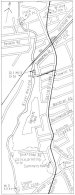 |
Fig.8: Route Plan (B) Earlsfield to Summerstown [78.8kb] |
At Franche Court Road the railway crossed Garratt Lane on the level, turned and ran close to its west side and continued across Summerstown about 20 yards west of its junction with Garratt Lane. It then ran roughly parallel with Summerstown, about 30 yards to the east of it, veering to run adjacent to it at the bend of the road. Bayliss showed the route here as adjacent throughout to the east side of Summerstown, but the Wandsworth Tithe Map showed it running alongside the rear garden fences of houses on the east side of the road (built later than the railway) and that route is still defined in places by boundary fences. The railway then crossed Plough Lane on the level.
| Wimbledon Mill |
McGow 37 |
| Calico Printing Works, Summerstown |
McGow 38 |
By 1834 it had become a silk mill, worked by Cornelius Payne and James Jones, who were declared bankrupt in December, 1834. The premises and plant were advertised for sale in February, 1835. The next silk printer there was Anthony Heath, who was still working in 1853, but in 1866 the occupants were recorded as Kayes, Leves and Wagland, silk and woollen printers at Garratt Print Works, and it continued in use as a print works until about 1900.
Returning to the Surrey Iron Railway at Summerstown, the route crossed Plough Lane, passing there from Wsandsworth parish into Streatham parish, and continued along the course of Mead Path alongside the Plough public house. This path is now only about 200 yards long, after which its original course is obliterated by recent industrial development, but until the late 1980s, it continued all the way to Colliers Wood, and followed, with small deviations, the route of the railway. From the end of the present Mead Path, to just north of the railway line from Wimbledon to Streatham, the route is defined by the western walls and fences of Lambeth Cemetery. In this length the railway passed from Streatham parish, through a corner of Tooting Graveney, and into Mitcham parish.
A replacement for the northern part of Mead Path was provided to the west, close to the Wandle, and this path turns to join the former route just north of the Wimbledon to Streatham railway. From this point Mead Path continues for about a third of a mile to terminate at Byegrove Road, but its original course has been
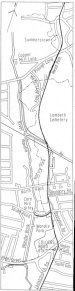 |
Fig.9 Route Plan (C) Summerstown to Colliers Wood [78.8kb] |
diverted in conjunction with nearby housing development in the 1980s and 1990s and no longer corresponds exactly with that of the railway.
The railway crossed Byegrove Road just to the west of its junction with Denison Road and went through the present Wandle Park, running beside a large meander of the old river course, and on to Merton High Street, which it crossed nearly opposite the junction with Valley Gardens. From the railway crossing at Byegrove Road, a branch ran along the western arm of this road to serve a corn mill on the Wandle. This branch was shown on the Wimbledon Tithe Map and was described on the accompanying schedule, dated 4 February 1848, as "tramroad". By this date, of course, the Surrey Iron Railway had been closed, and no doubt the track of the branch was taken up soon afterwards. The present building spanning the river on the site of the mill, now converted into flats, was formerly part of the works of Connolly Leather Ltd., who operated there from 1919 until 1993. The earliest mill here was a medieval corn mill, and later a fulling mill was built adjacent, which was subsequently converted to a brazil mill. In March 1690/91 they were both leased to William Knight, a London potter, who converted the brazil mill to producing pigments for use in his pottery. The corn mill continued in use as such, but the colour mill was later adapted for various other purposes.
In about 1796 both mills were leased to James Perry. He had been the editor and proprietor of The Morning Chronicle newspaper since 1789, and became a shareholder in the Surrey Iron Railway Company. He lived in Wandlebank House near the mills, and was a neighbour and friend of Lord Nelson during the period he was living in Merton Place.
| Merton Mill |
McGow 35 |
| Calico Printing Works, Merton (Merton Bridge) |
McGow 36 |
After its crossing of Merton High Street the Surrey Iron Railway turned to run almost due south, passing behind the present Colliers Wood Underground station, to meet the east side of Christchurch Road at about its junction with South Gardens. This length survived to be shown as a track on the 1865 Ordnance Survey maps. The railway continued its southward course adjacent to the east side of Christchurch Road. This road was at some time re-aligned, making a curve to 'the west between the junctions with Fortescue Road and Prince George's road, whilst the railway, following the former course of the road, ran on a shallower curve. The railway crossed Western Road at its junction with Christchurch Road and continued southwards along the east side of Church Road.
| Amery Mills |
McGow 34 |
In the final years of production, the business was conducted by the Dickinson Robinson group. In 1985 the buildings were demolished to make way for the Savacentre supermarket.
Adjacent to the copper mills was a calico- printing works established in about 1752 by Anthony Brown, James Loten, and
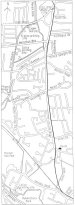 |
Fig.10 Route Plan (D) Colliers Wood to Mitcham [78.8kb] |
| Calico Printing Works, Merton Abbey, Merton (later William Morris) |
McGow 33 |
He was followed by a number of printers who occupied the works for brief periods. By 1820 Thomas Allchin, a silk printer, was working there, and he was succeeded by Edward Reynolds in 1830. In 1881 the best-known occupant moved on to the site - William Morris, poet and artist, who established workshops for the manufacture of stained glass, tapestries, and other products. He died in 1896, but the firm continued in business until about 1905 and its successor until 1940. In the mid-1940s the New Merton Board Mills Ltd. extended their premises to take over the whole of the Morris's site.
| Calico Printing Works, Merton Abbey, Merton (later Libertys) |
McGow 32 |
The earliest industrial use of the site was that of another calico-printing works, said to have been established in 1724, but it is not known who the first printers here were. John Cecill, who died in 1760, was recorded as being there in the 1750s. By 1780 Robert Maxwell was in occupation, but in 1784 he was succeeded by John Leach who, with various partners, operated there until 1806. In that year he and two of his partners assigned their interest in the business to James Newton, the then remaining partner. James Newton subsequently took into partnership, among others, William Simpson, who became the senior partner when Newton retired in 1812.
In 1820 Simpson moved the business to Wallington. The premises at Merton Abbey were then taken by Joseph Ancell, who was in partnership for a time with George Ancell, and who worked there until about 1834 when Edmund Littler moved on to the site. After his death in 1842, his widow Mary Ann carried on the business, and by 1865 her two sons had taken over. The main outlet for Littlers's products had been the firm of Liberty & Company, and in 1904 Liberty's took over the management of the works and were printing there until 1973- Silk-printing continued on the site until the works closed in 1983.
Another calico-printing works was established just to the south by John Leach in about 1795, which were occupied by John Bennett until about 1831. They were later absorbed into an extension of Littler's works.
| Mills near Phipps Bridge |
McGow 31 |
By 1793 the works were being managed by the partnership of Richard Howard, John Rivers, and Isaac Hellier and, later, Howard's sons Richard and James joined the firm. They were all proprietors of the Surrey Iron Railway. Section 85 of the railway company's Act of incorporation specifically prohibited any branch from the railway to Howard's works being extended beyond it, This seems to indicate that such a branch was originally contemplated, but there is no evidence that it was ever built. The firm evidently made use of the railway, for when its plant and effects were offered for sale by auction in September 1811, following the bankruptcy of its owners, an item of three railway wagons was included in the lots [17].
The premises were later leased to James Moore, who sublet to a succession of tenants, including Peter Wood, a silk-printer, who was followed by Thomas Wood in the 1830s. An indication of the use of the railway by a Mr.Wood in 1818 was mentioned in Chapter 7. Textile printing was carried on at the site until about 1870.
Returning to the Surrey Iron Railway, where we left it at Christchurch Road, crossing the junction with Western Road, it continued southward adjacent to the east side of Church Road, as far as Mitcham parish church. When the railway was built the course of this road was an unnamed track across the fields. According to Prentis,
"As late as about 1860 there was not a single house in Church Road beyond the church; which, within living memory continued to be nicknamed ''The Iron Road' by some local people. There may have been a stable for the horses of the Iron Roadway which ran on Church Road and it is reputed to have been near where Miles Road now is, in the premises of the paint works which had a number of small old brick buildings by the road up to recently. Anyway, that is the belief of some of the old men in the firm." [18]
It seems that the old men's belief is unfounded. Miles road is shown on the 1867 Ordnance Survey maps of the area, but there are no buildings marked near its junction with Church Road.
Where Church Road turns sharply eastward, just past the church, the railway continued almost straight ahead, then made a slightly curved sweep across the present works premises, and turned southeastwards to join the route of the former Wimbledon to Croydon Railway, now the Croydon Tramlink route, but on a higher level, about 70 yards east of London Road. It continued on this route in an easterly direction, crossing London Road on the level on the site of the present bridge.
At a short distance south of the crossing point, on the east side of London Road, was a brewery. This would seem to have been established in about 1766. In 1776 William Hughes acquired a half-share in the concern, and by 1800 he was the sole proprietor. After his death in 1805 it passed to John West and later to Marker Gaze. By 1817 it was known as the Globe Brewery. In the 1860s it was renamed the Surrey Brewery, and brewing carried on there until the 1940s. The premises were demolished in the 1950s.
A little further south, London Road crosses the Wandle, and between this point and Phipps Bridge there were a few mills, at some distance from the Surrey Iron Railway.
| Morden Hall Snuff Mills |
McGow 30 |
| Ravensbury Mill |
McGow 29 |
| Ravensbury Calico Printing Works, Mitcham |
McGow 28 |
Returning to London Road, where it crosses the river over Mitcham Bridge, there was a group of mills a short distance upstream. The first, a few yards east of the bridge on the south bank, was a snuff mill. This was erected in about 1788 by Richard Glover, possibly on the site of an earlier copper mill. By 1834 it was unoccupied, and it was demolished in the 1920s.
| Mitcham Mills (Later Grove Mill and Crown Mill) |
McGow 27 |
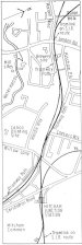 |
Fig.11 Route Plan (E) Mitcham [78.8kb] |
The Crown Mill was taken over by Richard Jones and converted to felt manufacturing and this continued until 1900. It was then put to a variety of uses until destroyed by fire in 1964. The Grove Mill was acquired by John Ashby in 1845, and worked by him and then his son Joshua until 1902. Then the premises were taken by the Patent Horse Hair Co. Ltd., later renamed Lxyhayr Ltd., which was there until the 1950s. The existing building was built following a fire in 1907.
With reference to these mills, R.Thurston Hopkins wrote in 1930: "should the reader be curious enough to search here in the tail-race of the mill stream he will find many of the iron wheels taken from the vehicles (i.e. of the Surrey Iron Railway) before they were broken up. Several of the wheels have been set up in the stream to form a sort of breakwater to protect the walls of the mill building." [19]
It was in the river here that the two wheels mentioned in Chapter 11 were found. Hopkins also wrote that ,the "mill building was formerly used as a repair shop for the railway", but this is misleading. Any repairs carried out by Richard Glover, who was certainly a user of the railway, would have been only to his own wagons.
On the east side of London Road, just north of where the Surrey Iron Railway crossed it, is a brick building with a central arched passage, which was used as Mitcham station booking hall until 1989, when it was converted into offices. It has been claimed that it was used in connection with the Surrey Iron Railway, but there is no evidence for this. Opposite this building, on the south side of the railway, were the premises of a coal merchant, shown in detail on a plan attached to a lease of l843 (Fig.12 ).
 |
Fig.12 Plan of coal merchant's premises at Mitcham, 1843 [78.8kb] |
The Surrey Iron Railway is commemorated in the name of Tramway Path, the road which runs from London Road along the south side of the railway route and terminates at Jessop Place. From opposite this point, where the Tramlink lines commence to curve towards the southeast, the Surrey Iron Railway made a wider curve, and at the east end of The Close, the continuation of Tramway Path is pretty well on its course. Bayliss showed the Surrey Iron Railway here exactly on the route of the Wimbledon and Croydon Railway, but the Deposited Plan of that railway and other contemporary maps clearly show the deviation. Nearing the bridge carrying Willow Lane, the Surrey Iron Railway route converges with that of the Tramlink. From Willow Lane, which the railway crossed on the level, the main line continued along the course of the Tramlink, while the branch to Hack Bridge curved away southwards. Before following the route of the branch, mention should be made of some mill sites nearby, down Willow Lane leading to the Wandle. The river here has been diverted; once there were two islands formed by the creation of bypass channels. The original course has been filled in, and the main bypass channel widened, and the islands have disappeared. On one was Mitcham Mill, which was actually in Carshalton parish. Originally built as a copper mill in about 1740, and worked by William Thoyts until about 1750, it was taken over by Edward Poster in about 1753 and converted to corn-milling. It passed to his son Charles Poster in 1766, and then to Charles's widow Mary in 1797. By 1817 John Searle was the miller there, and was succeeded in about 1847 by his son William, who was there until about 1872. In 1884 the premises became part of the Eagle leatherworks of J.S.Deed & Sons.
| Willow Lane Calico Printing Works, Mitcham |
McGow 26 |
| Logwood Mill, Mitcham |
McGow 25 |
Further up Willow Lane, on the west side, Richard Bond also established calico-printing works, in about 1712. After 1717 they were managed by Thomas Selby, and later by his son, also Thomas, until his death in 1751. He built a, house, later named The Willows, on the west side of Willow Lane, and another calico-printing works close by, a little further to the west. This was some distance from the Wandle, and was powered from one of a network of artificial channels which also supplied nearby bleaching grounds.
Thomas Reynolds took over the calico-printing here after 1750, and was succeeded by his son Foster Reynolds, who moved to Carshalton in 1785. George Sutherland managed the business from about 1798 until 1805. James Malcolm, describing the route of the railway, wrote that it entered Mitcham Common "by Mr.Sutherland's gate", that is, a gate across Willow Lane, at that period a private road. In 1824 Samuel Makepeace became the last calico-printer to work here, and he ceased production in 1845. Thereafter, silk-printing was carried on, on a small scale, until the mid-l850s. At some time Makepeace also took over a small print works to the southwest, on the east side of Willow Lane.
Some distance to the northwest of Willow Lane, on Mitcham Common, at the junction of Croydon Road and Carshalton Road, is the Ravensbury Arms public house, and beside it there were at one time some cottages named "Blue Houses". Of the origin of these, Montague wrote: "Horses used for pulling the trains of open trucks (i.e. on the Surrey Iron Railway) are said to have been housed in stables and sheds erected near the side of the present Ravensbury Arms. It has also been alleged that it was the custom to paint such stables blue, hence the name 'Blue Houses' by which the timber cottages standing on this site were known" [20]
There appears to be no evidence to support either allegation.
2) MITCHAM TO HACKBRIDGE
Prom the main line of the Surrey Iron Railway, immediately south of Willow Lane bridge, the branch to Hackbridge commences. There is another Tramway Path, starting just west of the bridge and running southwards to near the Goat Inn, behind the gardens of the houses in Carshalton Road and Aspen Gardens, but it does not correspond with the route of the railway. Bayliss showed the railway running adjacent to the east side of this path, but contemporary maps show that it curved away from the path, approximately on the line of the rear of the houses, apparently in order to skirt a small pond. This pond, and nearby property boundaries defining the route, are marked on the 1865 Ordnance Survey maps. Approaching Carshalton Road the railway passed in front of the Goat Inn and across Goat Road, the north side of which at this point defines the boundary between Carshalton and Beddington parishes. The Goat Inn was named on the 1800 Deposited Plan of the Surrey Iron Railway.
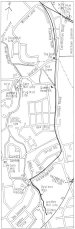 |
Fig.13 Route Plan (F) Mitcham to Hackbridge [78.8kb] |
| Leather Mill near Goat Bridge |
McGow 25 |
At the end of Goat Road the Wandle is crossed by Goat Bridge, and just upstream was a group of mills. Here an island was formed, on which stood a leather mill. The earliest mention of a mill there seems to be in 1680 when it was sold to Edward Wimblebee, a London leather-dealer. By 1744 it was in the occupation of the Savignac family. Pillett Savignac bought the mill in the early 1780s and worked it until his death in 1830. It was afterwards taken over by Peter Pharoah, and later by his foreman William McRae, followed by his sons until the 1880s. From 1890 until 1914 it was operated by members of the Roberts family, and it continued in use as a leather mill until1935. The old mill house, which was close to the mill, still survives.
Opposite the leather mill, on the east bank, was a drug grinding mill. Probably built around 1790, it was occupied in 1795 by Henry Batley. In 1815 Alexander Aitken took over, and it was worked by him and his descendants until 1909 when Norman Aitken surrendered the lease. The mill ceased working in about 1920.
Adjoining the drug mill was a small corn mill about which little is known. The earliest reference to it was in 1832 when it was being worked by George Chasemore. He was succeeded before 1849 by Charles Bourne, who was still there in 1862. The premises were later taken over by James and George McRae of the nearby leather mill.
| Wandle Tannery |
McGow 23 |
To the west of the drug mill were the calico-printing works of John Cookson & Company who became bankrupt in June 1792. The premises were advertised to be sold by auction in February 1793 and again in August. These included "a newly erected horizontal wind and water mill on an entirely new principle." By 1802, William Ansell, Thomas Chesson and Stephen Stevens were in occupation, when they dissolved their partnership. Chesson and Stevens carried on with a new partner, Edward Dudding, but Stevens left in 1809. Subsequently there was a succession of occupants, including John Cookson, who made a return in 1817. In April 1835 the works, then in the possession of D.Dixon, were advertised for sale. Production probably ceased soon afterwards. In the late 19th. century JT.& G.Miller's peppermint and lavender distillery was built on part of the site.
Returning to the Surrey Iron Railway at the Goat public house, its course continued southwards close to the west side of London Road. Just before the junction with Mill Green Road, a small tributary of the Wandle was culverted under the main road and the railway.
Close by is the Queen's Head public house, which was marked on the Deposited Plan of the Surrey Iron Railway. The railway continued its course adjacent to the west side of London Road until just before the junction with the present Longfield Avenue, where it turned westwards to cut off the corner at the junction with Hackbridge Road, then ran close to the northwest side of the latter road to its termination a few yards short of the Wandle just below Hack Bridge.
There was a bridge there in the 14th. century, sited a few yards downstream from the present structure. In 1793 George Shepley proposed to the Carshalton Vestry that he build a new bridge to replace the ruinous medieval one, in exchange for a piece of manorial waste land. His offer was not accepted, and in 1803 he prosecuted the Vestry for its failure to maintain the bridge in good repair. The indictment was later withdrawn, and a public subscription was set up to raise money to build a new bridge. In fact, most of the money was provided by Shepley, who decided that the bridge should be constructed of iron. The order for the ironwork, and for the stone for the abutments, was placed with Outram & Company. The materials were dispatched from Derbyshire on 31 August 1805, and the bridge was presumably erected soon after their delivery. This was one of the earliest iron bridges in the south of England. That bridge was demolished in 1912 and rebuilt in 1914. The present bridge was built in 1980.
| The Culvers Bleaching grounds and Corn Mills |
McGow 16 |
Just below the bridge the Wandle divides into two roughly parallel streams, uniting about 600 yards downstream and thus forming a large island. This was the site of the Culvers calico-bleaching grounds. Philip Selby leased the site in about 1744 and established the bleaching works. After his death in 1760 the business was carried on by his widow Ann until her death in 1777. Soon afterwards Foster Reynolds took over the grounds and after his death in 1797 was succeeded by his sons Thomas and Jacob Foster Reynolds. Manning and Bray wrote that there, "above two hundred acres of meadow land are frequently covered with cloth, most of the Russian and Irish fabrick." [21] James Malcolm referred to the bleaching grounds as "very extensive .:.. (and probably the largest in England)" [1]
Thomas Reynolds died in 1819 and was succeeded by his son Thomas Foster Reynolds. The partnership was dissolved in December 1824, and subsequently bleaching was carried on by Henry Curtis until about 1834 and had come to an end by 1837 when the estate was bought by the banker Samuel Gurney. Thomas, Jacob Foster, and another member of the Reynolds family, William Foster, were all proprietors of the Surrey Iron Railway.
Within the Culvers estate, spanning the western stream on the south side of the present Culvers Avenue, was Culvers Mill. The earliest reference to this seems to be on Senex's map of Surrey of 1729, whereon it is named Carshalton Mill. It was a corn mill by 1789, and probably was first built as such, and it continued to grind corn until about 1900.
Just north of the Culvers grounds, on the east bank of the river at Rushey Mead, was a calico-printing works which was probably established by George and Joseph Ancell prior to l808, initially in partnership with Benjamin Lay. Following the Ancells1 bankruptcy in 1812, their stock in trade was advertised to be sold in 1816. The premises were later taken over by the Reynolds.
| Hackbridge Mills, Carshalton, Beddington |
McGow 15 |
About 300 yards upstream from Hack Bridge is the confluence of the Wandle, the stream flowing from Carshalton, and that from Croydon. Hereabouts, when the Surrey Iron Railway was built, were three mills owned by George Shepley, which were the main reason for the construction of the Hack Bridge branch of the railway. The first mill on this site was a fulling mill, built before 1200. In 1289 the priory of St. Mary Overy held a half-share of it, and apparently obtained complete ownership by 1540 when it was surrendered to Henry VIII. In about 1569 it was converted into a brazil mill, and in about 1650 it became a gunpowder mill, and three other mills were erected nearby for the same purpose.
In 1661 the mills were taken over by Josias Dewye, who purchased the premises in 1692. After his death in 1698 gunpowder making was carried on by his nephew John Dewye, until about 1711. Two of the mills were then converted to copper-milling.
In 1765 George Shepley and his partner Hugh Mears took the lease of the mills. By this period one of the original four mills had fallen into ruin and another was used for logwood grinding. Shepley and Mears converted all three working mills to leather dressing. One mill was situated on the east bank of the Croydon branch of the Wandle just above the point of confluence, and the others faced each other on opposite sides of the river just below that point.
Hugh Mears retired in 1777, and Shepley carried on alone, but later took his sons Richard, Michael, and Hugh into partnership. Following the bankruptcy of John Bewye Parker, the then owner of the mills, in 1788, Shepley purchased them and the adjoining land. Some years before he bought the property, Shepley had converted one of the mills to the production of linseed oil, which was used in his leather dressing process, and in 1778 the engineer John Smeaton designed a new wheel for the oil mill. It was to this mill that Shepley built a single-line branch from the Surrey Iron Railway terminus at Hack Bridge. It ran close to the east bank of the river, alogside a private road. (Fig.14).
Following George Shepley's death in 1807, the property passed to his eldest son Richard. Richard Shepley died in 1808, and "bequeathed the mills to his only son George, who was then only about seven years old. Until he came of age his estates were administered by three trustees, chiefly by Michael Shepley, Richard's brother. Michael Shepley maintained the family business and managed the mills until George came of age in 1822. In 1825 George Shepley leased the mills, which by this time had been reduced to two, the leather mills having been rebuilt as one structure spanning the river. This was leased to Alexander Ross, and then in 1839 to William McRae, both leather dressers, and then in 1850 the lease was taken by Mark Markwick, a "patent Epithem manufacturer".
The oil mill was leased in 1825 to Daniel Watney of Wandsworth and by the terms of the lease he was given the right to use the "Tram Road or Iron Railway leading from the Surrey Iron Railway"[22] . Oil milling continued there until 1854, when the mill was leased to Charles Pox, a woollen manufacturer, and later the Carshalton Wool Company was the tenant. In the early 1860s it was converted to snuff milling by Robert Lambert, who was succeeded by his son Alexander in about 1888. He worked there until 1912 when the premises were taken over by Arthur Coles & Company, calico printers, who were there until the 1940s. The building was later used by Copes Football Pools, who were there until the 1960s, and it was subsequently demolished.
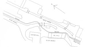 |
Fig.14 Plan of private branch to Oil Mill, Hackbridge,. 1825 [78.8kb] |
Back at the leather mill, Mark Markwick was followed in 1861 by Edwin Frost, a leather dresser, and after his death in 1872 the business was carried on by his widow and later his son, also Edwin. He was in occupation until some time after 1901, and by 1905 Beach & Sons Ltd. were working there. By 1927 the Hackbridge Chamois Leather Company Ltd. was operating the mill and was there until the 1940s. It was later absorbed into buildings erected by Gilbert White, engineers, who still occupy the site.
George Shepley the younger died in l835, and his estates passed to his three sisters, Susanna Mary, Georgina, and Lydia Jane, in equal shares. The ownership became more widely spread following the marriages of Georgina and Lydia Jane and the involvement of their husbands and also that of their half-brother William Frederick Harrison. In 1879 Susanna Mary Shepley became the sole surviving owner, and after her death in 1882 the name of Shepley ceased to be associated with the mills. However, the Shepley lineage, in part, continued to own the mills for a little longer. Miss Shepley bequeathed the estate in half-shares, one to her grandnephew Charles Hofmann, and the other half to the four children of her late sister Georgina. The properties were sold during the next few years, and the Carshalton estate was purchased by Edwin Curtis Good in 1888.
3) MITCHAM TO CROYDON
From Willow Lane at Mitcham where the branch diverged to Hack Bridge, the main line of the Surrey Iron Railway continued in an easterly direction across Mitcham Common, on the course of the later Wimbledon to Croydon Railway and the present Tramlink. This is practically on a staight line for just under a mile, to Beddington Lane. This point was on the edge of Mitcham Common, and on the boundary between the parishes of of Mitcham and Beddington. Continuing on a slight curve to the southeast, the railway crossed from Beddington into Croydon parish, where it passed the end of the present Alfriston Avenue, and continued, still on the Tramlink route, to the site of the former Waddon Marsh station on the Wimbledon - Croydon Railway, about 150 yards southeast of Purley Way.
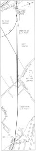 |
Fig.15 Route Plan (G) Mitcham to Croydon [78.8kb] |
| Waddon Mill |
McGow 4 |
Purley Way is the successor of a lane, on much the same route, which ran southwards to Waddon, and just to the west of that village, on the Wandle, was Waddon Mill. This was of Saxon origin and was probably the Croydon mill referred to in the Domesday survey. It was a corn mill for the whole of its existence.
By 1793 it was in the ownership of John Hilbert and occupied by Daniel Watney, who worked the mill until about 1822. From 1823 until his death in 1828 the miller there was William Rayley. In 1830 Daniel Watney's son, also Daniel, became the tenant and by 1839 he was also the owner.
| Malt Mill at Waddon |
McGow 3 |
The mill continued in use until 1928. It was situated at the west end of Mill Lane, where part of the mill pond still remains as Waddon Ponds. Although about half a mile from the nearest point on the Surrey Iron Railway, the fact that Daniel Watney also had an interest in mills at Wandsworth suggests that he may have made use of the railway. It is interesting to note that a branch from the later Wandsworth and Croydon Railway ran from just north of Waddon Marsh station to serve Waddon Mill.
To the northeast of the railway at the site of the station, in the vicinity of the junction of the present Ringwood Avenue with Ockley Road, there was once a brickworks, with a footpath connection to the Surrey Iron Railway, which suggests that coal for the kilns may have been delivered by this route.
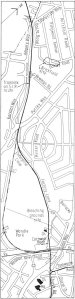 |
Fig.16 Route Plan (H) Croydond [78.8kb] |
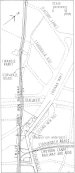 |
Fig.17 Plan of Surrey Iron Railway terminus at Croydon [78.8kb] |
| Calico Printing Works near The Barracks, Croydon |
McGow 2 |
From the site of the station the railway turned towards the east, leaving the Tramlink route, to connect with the course of the present Enterprise Close. Where this road turns to join Factory Lane, the railway continued straight ahead, cutting off the corner, then turned to the right to join the route of Factory Lane. That part of Factory Lane running from this point southeastwards to the corner at the entrance to Stubbs Mead Depot, was built on the railway route after its abandonment. On the north side of Factory Lane, just after the sharp turn at the depot entrance, was the barracks mentioned by James Malcolm in his description of the route of the railway, which were established in 1794 to house three cavalry units. The present Territorial Army headquarters buildings occupy the same site.
Stubbs Mead Depot is named after, and occupies part of the site of, Stubbs Mead, on which was situated a calico-bleaching ground running down to the Wandle, now culverted across Wandle Park. Malcolm in 1805 recorded that here were the calico-printing grounds of Messrs.Lane and Lay.
| Calico Printing Works and Bleaching Groundsat the Old Palace, Croydon |
McGow 1 |
At the bend of Factory Lane at Stubbs Mead depot the Surrey Iron Railway continued straight ahead, entering the present Wandle Park a few yards inside the gate at the end of the present Theobalds Road. Hereabouts the railway crossed over a tributary of the Wandle, probably by a plank bridge. Running through the church hall site, the railway crossed the present Cornwall Road, then ran along its east side to cross the later Croydon and Epsom Railway and thence to its terminus at Pitlake.
This was on a site covering the present pedestrian underpass from Cairo New Road to Lower Church Street beneath Roman Way Jubilee Bridge, and extending into the adjacent car park. Fig.17 shows the extent of the buildings there in about 1844. These included a house, stable, forge, timber yard and warehouses. There was also a toll house with weighbridge, but this was probably situated a little to the north of the terminus, where contemporary maps show a building adjacent to the east side of the railway, a few yards north of the present Cuthbert Road near its junction with Cornwall Road. Unfortunately, as in the case at Wandsworth, no maps have been found which show the track layout at the terminus. One supposes that there was at least a run-round siding or a turntable, but none such are mentioned in contemporary documents.
|
|
|
|