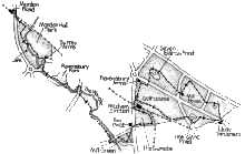
From Mitcham Junction tram stop you can take a 2 3/4 mile circuit of Mitcham Common or a 3 mile linear walk down the Wandle to Morden Road tram stop, or combine the two for a longer outing.
Mitcham Common circuit. Mitcham Junction tram platforms have their own sloping path up to the main road. Climb this, and turn right to cross the rail bridge. Just beyond the old station drive, look for a wellconcealed gap in the wire fencing on the right, where paths lead out onto the public golf course.
Once on the course, turn left on a path that follows its edge. Coming to a branching of ways, the left fork leads to a road and the Ravensbury Arms, but you take the right fork. This path runs near the busy road, Croydon Road, and when it soon comes out right beside the road, cross with care and find a rather narrow path opposite, onto the main common. It crosses a major path and keeps on to reach Seven Islands Pond, one of several left after 19th century gravel extraction.
Pass the pond and turn right on the track that keeps the water to its right. Where the pond ends, follow the mown track that climbs the gentle hill slope ahead - a hill created quite recently by the capping over of an old rubbish tip. Over the brow, with views all around, the track drops through trees to the Mill House pub.
Here you can still see the king-post timbers of a windmill built in 1806 and badly damaged by a lightning strike in 1862. From the car park in front of the nearby Ecology Centre, go left on a gravel path. Where it reaches a road with houses beyond, turn sharp right on the horseride that follows the common edge. It crosses a lane, and immediately after, fork left on a path that climbs another gentle rise, soon passing a little pond to its right. Just beyond the pond, a lesser path forks right through the grass, joining up with several other paths in due course, on the main road opposite the Jolly Gardeners pub.
| [Full size image 19kb] |
For the Wandle walk, turn left instead of right, at the top of the slope up from the Tramlink platforms. Almost immediately you can turn left again through green posts to paths onto the triangle of common known as The Gunsite. The army occupied this area in World War II with a battery of anti-aircraft guns, but as it has not been dug for gravel, this is the best example of unspoilt acid grassland on the common. Keep ahead on the path that follows near the railway, and into a belt of young oak woodland. Where a footbridge comes over the rails, turn right on a woodland path which emerges at a road junction opposite The Goat pub. Cross the little central plot and take the metalled path setting off leftwards across the middle of open grass. It crosses a water channel and comes to a road. Just before the road you can bear right on a path along the common edge, joining the road to cross the Mill Green Ditch but then coming to open grass again where you can cut a corner, keeping near the left hand road. Coming to a road junction, keep ahead on the main road, which very soon crosses the Wandle. Here you can use. pedestrian lights and turn down Watermead Lane opposite. After passing an attractive little terrace of cottages, this becomes a metalled path beside the river.
After a while, the path leaves the Wandle bank to keep outside the fence of Watermeads Nature Reserve. Coming to a main road, turn right to cross the Wandle, then over the road at a pedestrian island and back to a path that rejoins the riverbank. The path circuits round a lawn, then crosses a footbridge to continue, now with the Wandle to its right. Another footbridge leads into Ravensbury Park, where you turn left to follow the main Wandle channel, now opening up into an ornamental lake. Coming up to another main road, a pair of millstones and a weir tell you that this is one of the many mill sites along the Wandle. In its day, the fast-flowing Wandle powered over 90 mills, but only a few remain.
In the road turn right, cross at pedestrian lights then, just before the Surrey Arms, go left via a wooden gate into Morden Hall Park. Inside, bear left to cross the fine avenue and take the metalled path beyond, which curves right and into trees. Gates take the path through a delightful rose garden with views of Morden Cottage, then you rejoin the avenue, turning left to cross the Wandle via a footbridge with ornate cast iron balustrades. Over the bridge, the path on the left leads to the snuff mill, garden centre and tearooms, while the walk goes ahead, bending right to cross more footbridges. Take the right fork signed to Deen City Farm' then, just before the path comes to the tram tracks, bear left on a path that keeps just within the park. It finally exits via a fence gap and .up to a road, where you turn right. Steps soon take you down on the right, under the road and out to the platforms of Morden Road tram stop.
|
|
|
|