


|
|
|
|
|
|
|
|
|
The river Wandle was just over 9 miles long. It had a drop of 124 feet from the start to its end, making it a very fast flowing river. It was too fast for boats, but was ideal for waterwheels. At its height (1890-1910) there were up to 90 mills on the river. Merton Abbey Mills is the only 'working mill' left. Liberty sold the mills in 1977 to Merton Fabrics who used them till 1981. They then stood empty and neglected tor 5 years when they were renovated and turned into shops at a craft village in 1989 paid for by Sainsburys.
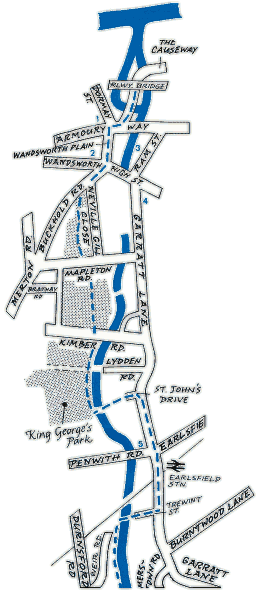
North of Armoury Way, The Causeway leads to the mouth of the river and its confluence with the Thames. A branch of the Wandle - Bell Lane Creek - forms Causeway Island. Currently there is no access to the riverbank beyond the Railway Bridge. The Wandle Trail commences at the point where The Causeway crosses the Wandle but it is not yet signposted here. The Trail also connects here with the Thames National Path, which crosses the Wandle mouth on a new bridge.
The Wandle can be seen from Wandsworth High Street by the side of Young and Co. where a brewery has stood since at least 1675 [3] and close to where the Surrey Iron Railway terminated at Ram Field. The brewery retains many of the stone sleepers from the railway in the yard where it exercises its famous draught horses which pull the Company drays.
Crossing the road past the Arndale Centre and into Garratt Lane, the new Wandsworth Museum [4] in the Old Courthouse is worth visiting (Open from early 1996). The Wandle Trail continues just south of the Arndale Centre in Buckhold Road, where it is signboarded as Cherry Tree Walk and enters King George's Park, which forms the major green space around the Wandle in Wandsworth. The path continues through the park and eventually crosses the river through the Henry Prince Estate and up St. John's Drive to join Garratt Lane.
Here the river is inaccessible and the route continues through Earlsfield past the Sailor Prince to Trewint Street. From Trewint Street Bridge a walkway leads along the West Bank of the river to Plough Lane, where Wimbledon Stadium [6]is at the junction with Summerstown.


