The Wandle offered wonderful trout fishing up to the latter part of the last century. The Wandle Trail was established by the Wandle Group in association with the Wandle Industrial Museum in September 1988, launched with a walk with over 200 participants, led by Colin Saunders. 'The Wandle Trail Map and Guide' (Item E02 in the Shop) was put together in 1996 by the Wandle Industrial Museum with the support and help of London Borough of Merton, and sponsorship from Brown and Root. It is now at the core of the efforts of the Wandle Group and we are integral to the Wandle Trail Working Party, which includes all the 4 Wandle Boroughs, Wandsworth, Merton, Sutton and Croydon.
This original guide aimed to encourage and assist those who wish to explore the River Wandle and its heritage. Whether taken as a short stroll or a long walk it provided a brief outline of the main points of interest and the principle features of the route.
The full length of the Wandle Trail is a 11.5 mile long route that follows the River Wandle from Sutton, through Merton to where it enters the Thames in Wandsworth. Two thirds of the riverside is accessible to the public. It is hoped that in the future the walkway will be extended and improved. In the meantime sturdy footwear is recommended.
One of the main changes since 1996 has been the opening of Croydon Tramlink, whose stations at Phipps Bridge, Belgrave Walk, Mitcham, Ampere Way and Waddon Marsh all service the Trail. The line is broadly the same as the railway shown in the Guide, but more stations have been added. See more detailed information about the Croydon Tramlink on its website.
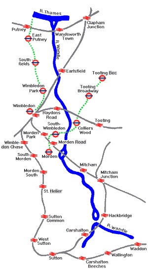
The Travel Map [Full size image 76.5kb] to which you can link by clicking here, or from the 'key' icon on each page(under 'Overview), is based on the original rail layout, and will be updated in the next edition to differentiate between the railway, and Tramlink
Every effort has been made to ensure accuracy of the map and the information contained. However at any given moment there may be a number of changes in effect or pending which may alter the route.
The text in this site which accompanies the guide has been updated somewhat already, but does not include all the images and information which can be found in the Map and Guide itself, or in the book �The Wandle Trail' published by the Museum (�1.50p) or the �Wandle Guide' book published by Sutton Leisure Services for the Wandle Group (�4.95p), as well as the smaller booklets referred to in these notes, all available in the Shop or by mail order.
Landscapes of History
Today the area around the River Wandle combines gracious parkland and industrial wasteland, urban street and garden suburb, far removed from the rural landscape of earlier centuries when the river margins harboured bleaching fields, osier plantations and watercress beds.
Successive generations have left their mark on the landscape. Many of the parks through which the Wandle flows are formed by the remnants of manors, estates and pleasure grounds laid out by the gentry and the prosperous to express their wealth and status.
However nothing was to have such a profound impact on the river as the demands of water-powered industries. This continuously redefined the Wandle during the centuries in which mills proliferated, manufacturing copper and iron, oil, leather, paper, snuff and printed textiles. The Surrey Iron Railway, the first public railway in Britain, operated from 1803-46 using horse-drawn waggons to transport goods as far as the Thames at Wandsworth.
From the late 19th century onwards a tide of house building engulfed the valley, transforming Surrey villages into London suburbs. The Wandle diminished in significance and decreased in flow. Fortunately at the same time individuals began to work together to protect the environment and its heritage; a task which is continued through a variety of organisations to the present day.
Note:
On pages 2 to 6 you will find the pages dealing with individual sections of the Wandle Trail. At the bottom of each page you will find the 'Key' sign which will take you to a list of the place numbers appearing on the maps, identifying them by name and description.
Note:
If your browser does not support frames, there is a text only index to this section of the site
Founded in 1995 to promote the physical and natural environment of the Wandle Valley in South London.
With interactive maps showing location and transport routes.
Sustrans web pages commenting on their partnership with Groundwork on the Wandle Trail, with particular reference to the new waymarkers and works of art.
Sustrans web pages commenting on their partnership with Groundwork on the Wandle Trail, with particular reference to the new waymarkers and works of art.
The Wandle Industrial Museum would like to take this opportunity to thank Brown & Root, Surrey Scanning and Merton Council for their help in producing this leaflet.
For a comparison between our map, which concentrates on the historical context of the Wandle Trail, and the new initiatives on the trail under the aegis of Groundwork, visit their new website www.wandletrail.org. If you can not get a hard copy, LB Merton supply a pdf version


 The full length of the Wandle Trail is a 11.5 mile long route that follows the River Wandle from Sutton, through Merton to where it enters the Thames in Wandsworth. Two thirds of the riverside is accessible to the public. It is hoped that in the future the walkway will be extended and improved. In the meantime sturdy footwear is recommended.


